Mapping Detroit: Green Book Locations
Green Books mirrored the state of discrimination, racism, and African American rights in the nation each year. Detroit’s listings started in 1938.
Functioning as a vital directory during the Jim Crow era, the Green Book was an “underground railroad” of a different kind. It helped African Americans map the most welcoming routes, listing vacation spots, hotels, beauty parlors, service stations, and mechanic shops. It also regularly included state-specific traffic laws and issues for Black motorists to be aware of.
Detroit’s listings first appeared in the 1938 edition, featuring 9 hotels, 2 night clubs, and 1 service station, all concentrated in a high-density area of non-White residents. By 1949, the city’s extensive entries reflected its status as a mecca for Black tourism and entertainment during the height of Paradise Valley. Predictably, these Green Book locations aligned precisely with areas of Detroit that had higher numbers of Black residents, a result of restrictive and discriminatory housing policies. The 1949 edition also broadened its scope to include Canada and Mexico.
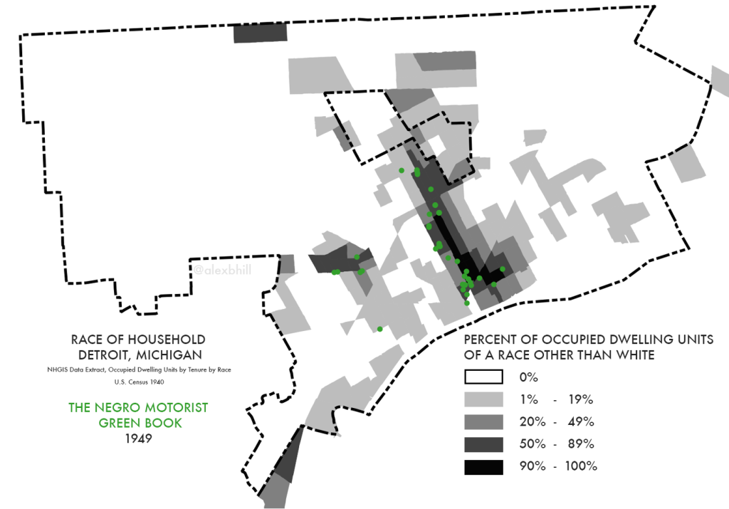
In a sense, the Green Book mirrored the state of discrimination, racism, and African American rights in the nation each year. Today, visible displays of racism persist. My research on food access often reveals that people still rely on word of mouth to avoid discriminatory grocery stores. It is sobering to imagine that a directory of this nature may still be maintained unofficially. We have substantial work ahead to ensure that everyone can travel with dignity and without fear, both in their own cities and in those they wish to visit.
Thanks to the Green Books collection at NYPL’s Schomburg Center for Research in Black Culture for making these texts available.
This is a part of the Mapping Detroit series from cartographer, Alex B. Hill, a self-described “data nerd and anthropologist” who combines mapping, data, and analytics with storytelling and human experience. He is the founder of DETROITography and author of Detroit in 50 Maps and Great Lakes in 50 Maps.
Author

Related Articles

HISTORY LESSON: Detroit’s March Madness: The Moments That Never Get Old
As Michigan competes in the winner-takes-all NCAA Championship, let’s reflect on other key March Madness moments in Detroit history.
HISTORY LESSON: The significance of the Palmer Park Historic District
Palmer Park’s 57 apartment buildings represent one of Detroit’s clearest examples of intentional, high-quality multifamily planning.

Tracking history through stories
Long-time residents of Woodbridge tell stories of their diverse Detroit neighborhood through an oral history project meant to capture the essence of life in the area in decades past.

