Mapping Detroit: Why are Detroit streets numbered the way they are?
Once described by another cartographer as “delightfully pointless” to map, the patterns and variations of street numbering across US and international cities continues to spark curiosity. Examples range from numbering systems by street in Berlin, Germany, to city-county numbering in Hamilton County, OH, and even typographic font choice in Arlington, VA. Plenty of fun maps exist, but in the end house numbering has to do with taxation. Well planned and documented house numbering exists so that tax bills can easily be sent.
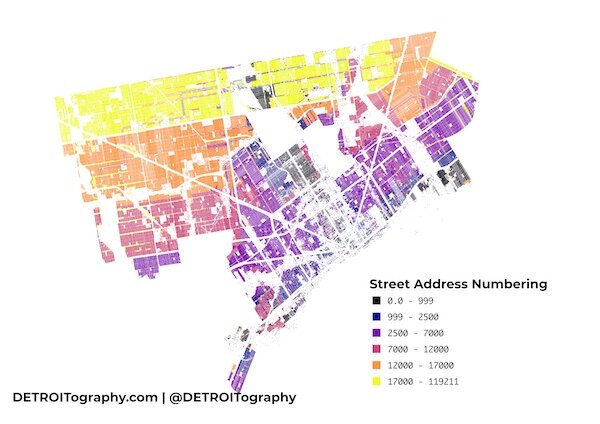
In Detroit, all streets were renumbered in 1920. Effective on January 1, 1921 the numbering scheme that is used today in Detroit remains, however you can still see the remnants of Detroit’s past urban planning and community development efforts.
The historic city center and areas along the riverfront retain the lowest numbers along with the oldest streets that run North-South. Detroit annexation expanded the land area of the city as well as the dominance of East-West streets. Much of the purple falls below Harper Avenue while everything in yellow is above McNichols/Six Mile.
Author

Related Articles

A vision for mushrooms as part of Detroiters’ everyday wellness routine
A Detroit mushroom farm and cafe owner bet on his city, and the response is sprouting business growth and expansion.

Detroit has community buy-in for Solar Neighborhoods Initiative
With 139 square miles of land – some blighted or unused and ripe for repurposing – Detroit is well-positioned to develop solar farms to help power city buildings.

Composting project empowers Detroiters to reduce food waste, protect the environment
Food waste makes up one-quarter of landfill waste and contributes to more methane emissions than other landfill materials. The Detroit Community Composting Collective Project is out to curb food waste by training backyard composters.

