An inside look at the transformation of the Detroit riverfront
In the past decade, so much has changed along the riverfront. But even more has been announced for the future. MJ Galbraith spoke with planners and developers to present a full picture of all the developments taking place.
In the myriad of ways that Detroit has changed over the past decade or so, the transformation of its riverfront is one of the starkest in the city. What once was a largely inaccessible patchwork of private property scattered with industry and parking lots has since become one of Detroit’s busiest public spaces.
Those developments were set in motion in 2003 with the 4.5-mile Detroit RiverWalk and a few years later with the nearly two-mile Dequindre Cut, triggered by land purchases and transfers from General Motors and the city of Detroit, and the formation of the Detroit RiverFront Conservancy.
But for all the drastic changes since then, the riverfront is developing even faster now.
The Detroit RiverFront Conservancy, the non-profit tasked with stewarding the riverfront’s public spaces, works in tandem with public and private partnerships to create a larger framework of development. And though private developers’ interest in the greater downtown hasn’t been this high in decades, the Conservancy and the city itself has established a commitment to maintaining its mission of the riverfront remaining and growing as a public space as much as possible.
As president and CEO of the Detroit RiverFront Conservancy, it’s Mark Wallace’s job to uphold that mission.
“We focus on public space first and foremost,” Wallace says. “But we don’t just want to put imaginary buildings on a rendering. These are changes we know we can accomplish soon.”

The RiverWalk is more than 80 percent complete when compared to its 5.5 mile-long goal. Much of the Conservancy’s plans aim to fill in the gaps as well as further enhance the already developed spaces. The RiverWalk will eventually stretch from Belle Isle to the east to the Ambassador Bridge to the west.
Set to break ground in the near future is Atwater Beach. Although it won’t allow for swimming access, the beach will feature sand, a grassy area dotted with trees, a playscape, and a performance shed. A new pedestrian bridge and a floating barge café will connect a crucial gap of the RiverWalk, allowing for uninterrupted travel from Stroh River Place to Chene Park East.
Some time in the first quarter of 2019, the Conservancy will break ground on the old Uniroyal site. The 43-acre plot of land separates Mt. Elliott Park, the eastern end of the RiverWalk, from Belle Isle. Several years and millions of dollars of environmental remediation for the once heavy industrial site will soon pay off, allowing the RiverWalk to connect to Belle Isle and its MacArthur Bridge.
“We’ve found that people want a connection to Belle Isle as soon as possible,” Wallace says.
There are still more improvements planned for the East Riverfront. The district made the news in March 2017 when city planners announced its strategic framework plan for the area. The Detroit RiverFront Conservancy, the city of Detroit Planning & Development Department, and the Detroit Economic Growth Corporation held several months worth of community engagement, holding discussions, meetings, and tours with residents and stakeholders.
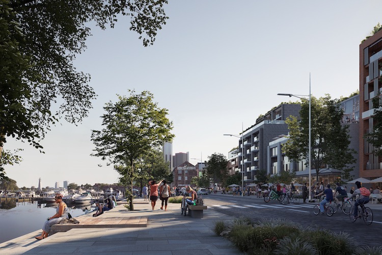
What resulted was a deeper commitment to public space, with three planned private developments scrapped in favor of eight extra acres of park space. Milliken State Park & Harbor will expand. East Jefferson Avenue, which has already seen non-motorized transit improvements, such as protected bike lanes, will be made safer for pedestrians to cross and access the riverfront.
“The riverfront belongs to all Detroiters,” Maurice Cox, director for the city of Detroit Planning & Development Department, said at the time. “Thanks to the involvement of hundreds of residents, we have principles that frame an international riverfront that can be accessed and enjoyed by all.”
Mark Wallace echoes that sentiment today. “As we build, we want to continue to get input and broaden the groups of voices we listen to.”
Also planned are two more Dequindre Cut-style pathways: Joseph Campau Greenway, which will run from the Detroit River to Vernor Highway, and Beltline Greenway, located between Belleview and Beaufait streets, which will run from Kercheval Street to the riverfront. All three greenways are viewed as critical pedestrian-friendly access points, drawing residents from their neighborhoods to the riverfront.
And that’s just the east side. Travel west and the RiverWalk seemingly ends at Joe Louis Arena. A visitor unfamiliar with the city would be forgiven for not realizing that the RiverWalk picks back up at West Riverfront Park. But Wallace says that the Conservancy has received easements from property owners to extend the RiverWalk and connect the gap interrupted by Riverfront Towers and other parcels of land there.
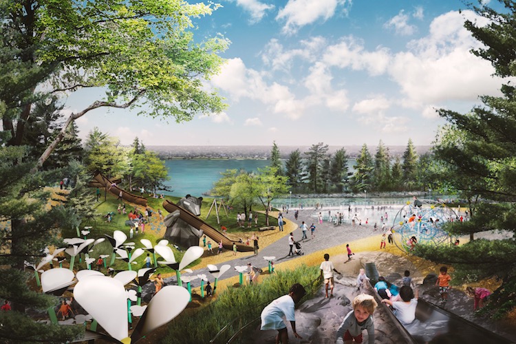
West Riverfront Park itself is scheduled for a major overhaul. The Conservancy held more rounds of community engagement, even going so far as to fly 21 community advisors to New York City and Philadelphia to study the great parks there. An international design contest was held for the $50 million redevelopment of what is now mostly an open grassy field.
New York firm Michael Van Valkenburgh Associates was ultimately chosen for the redevelopment. Plans for the 22-acre park include a cove that comes into the park from the river, stone jettys, a kayak launch, a sandy beach, a performance hill, sport, pool, and maker houses, what Wallace describes as an “iconic” playground, and much more. Trees, hills, and extensive landscaping run throughout the renderings.
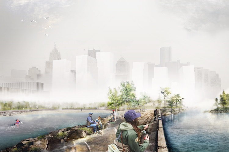
That leaves roughly one more mile to reach the Ambassador Bridge, the end goal for the RiverWalk’s westward expansion. Completing the 5.5 mile stretch has always remained the Conservancy’s ultimate vision.
With each development, a unique experience punctuates every few steps along the RiverWalk. “A system of public spaces is more powerful than one big one,” Wallace says.
That focus on public space has made the Detroit riverfront an increasingly desirable place to live. And just as organizations — including the city’s planning department, the DEGC, and the Conservancy — work together to maintain and grow public access to the riverfront, they also regularly check in with each other to help guide the private development that does happen.
The DEGC itself has more than ten acres slated for development, with some RFPs scheduled for announcements within the next few weeks, and all adjacent to or nearby the riverfront. The developments emphasize mixed-use and mixed-income that increase density throughout the district.
Sarah Pavelko, senior real estate manager for the DEGC, says that the riverfront can be a place for both public spaces and private developments. The former attracts the latter, and vice versa.
“I think it’s a false dichotomy, pitting public against private,” Pavelko says. “You can’t have one without the other. That’s the reason people move to big cities.”
Recently completed developments include Waters Edge at Harbortown, Orleans Landing, and the nearby DuCharme Place, which added 175, 275, and 185 residential units to the east riverfront, respectively.
And more are coming. A mixed-use redevelopment of the historic Stone Soap building could see a groundbreaking within months. Another is the $40 million senior housing complex from Presbyterian Villages of Michigan.
It’s just the beginning of what’s likely to be wave after wave of mixed-use development announcements for the riverfront. It’s a desirable place to live and much of the credit can go to organizations like the Detroit RiverFront Conservancy, which has spent a decade and a half cultivating more than six miles of public space.
“There’s a lot going on but these are things that we’ve wanted to do for 15 years,” Wallace says. “A window of opportunity has opened for us and we want to move through it as fast as we can.”
